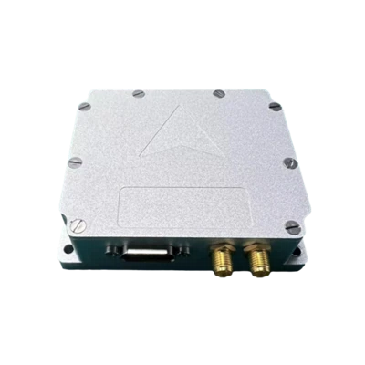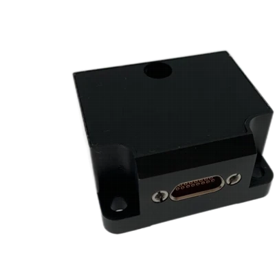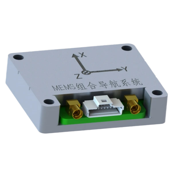
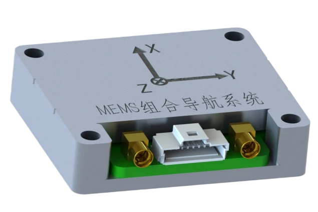
MSI105 Micro MEMS Inertial Navigation System
High performance, compact size, lightweight
Full-band GNSS, high precision
Steady-state power consumption of 0.5 W
Description
Key Features
- High performance, compact size, lightweight
- Full-band GNSS, high precision
- Steady-state power consumption of 0.5 W
- Full-temperature compensation from -45°C to 80°C
- Optional adaptive attitude and heading
- Online upgrade capability, lever-arm compensation
- Self-correction without GNSS
- RTK differential support
Applications
- SATCOM-on-the-move
- Position and attitude reference for UAV/UGV/USV
- Attitude control
- UAVs and USVs
Product Description
Company MSI105 Micro MEMS integrated navigation system is a compact and cost-effective MEMS inertial integrated navigation system, mainly targeting navigation, control, and measurement fields represented by SATCOM-on-the-move and UAVs. The system highly integrates MEMS sensors and full-band satellite receiver chips within a small footprint, enabling positioning and attitude measurement in a compact volume.
Unique Technology
Company is a high-tech enterprise with full closed-loop capabilities from fiber winding equipment and coils to FOGs, fiber/MEMS inertial products, IMU circuits, software, and test equipment. End-to-end process control improves quality and reduces costs. Operating under ISO9001 with strict processes, it ensures product reliability and consistency.
Performance Parameters
MSI105 Micro MEMS Inertial Navigation System Performance Specifications
|
Parameter |
Specifications |
|
MEMS Gyroscope |
|
|
Range (°/s)° |
±300 |
|
Full-Temp. Bias (°/h)° |
≤360 |
|
Bias Stability (°/h, 10s avg.)° |
≤10 |
|
Bias Instability (°/h, Allan) |
≤3 |
|
Bias Repeatability (°/h)° |
≤10 |
|
Angular Random Walk (°/√h) |
≤0.3 |
|
Scale Factor Nonlinearity (ppm) |
≤100 |
|
Cross-Axis Coupling (rad) |
≤0.001 |
|
Bandwidth (Hz) |
≥100 |
|
MEMS Accelerometer |
|
|
Range (g) |
±16 |
|
Bias (mg) |
≤5 |
|
Bias Stability (µg, 10s avg.) |
≤300 |
|
Bias Stability (µg, Allan) |
≤50 |
|
Bias Repeatability (µg) |
≤300 |
|
Velocity Random Walk (mm/s/√h) |
≤50 |
|
Scale Factor Nonlinearity (ppm, ±1g) |
≤300 |
|
Cross-Axis Coupling (rad) |
≤0.001 |
|
Bandwidth (Hz) |
≥100 |
|
Integrated Navigation Accuracy |
|
|
Integrated Horizontal Position (m, 1σ) |
3 m (Single Point), 0.02+1 ppm (RTK) |
|
Integrated Vertical Position (m, 1σ) |
5 m (Single Point), 0.03+1 ppm (RTK) |
|
Integrated Horizontal Velocity (m/s, 1σ) |
0.1 |
|
Integrated Vertical Velocity (m/s, 1σ) |
0.15 |
|
Integrated Heading (°, 1σ, Real-Time) |
0.2 (1m Baseline Dual Antenna), 0.5 (Single Antenna, Dynamic) |
|
Integrated Horizontal Attitude (°, 1σ, Real-Time) |
0.1° (Dual Antenna), 0.2° (Single Antenna) |
|
Parameter |
Specifications |
|
Electrical/Mechanical Interface |
|
|
Power Supply (V) |
5 V (Ripple ≤ 100 mV) |
|
Steady-State Power (W) |
≤0.5 |
|
Startup Time (s) |
≤3 |
|
Communication Interface |
UART |
|
Max Update Rate (Hz) |
100 |
|
Dimensions (mm×mm×mm) |
41.5×35.5×9.5 |
|
Weight (g) |
<30 |
|
Operating Environment |
|
|
Operating Temperature (°C) |
-40~+85 |
|
Storage Temperature (°C) |
-55~+85 |
|
Vibration (g, RMS) |
20~2000 Hz, 4.08 |
|
Shock (g) |
1000 g/1 ms |
|
Reliability |
|
|
MTBF (h) |
10000 |
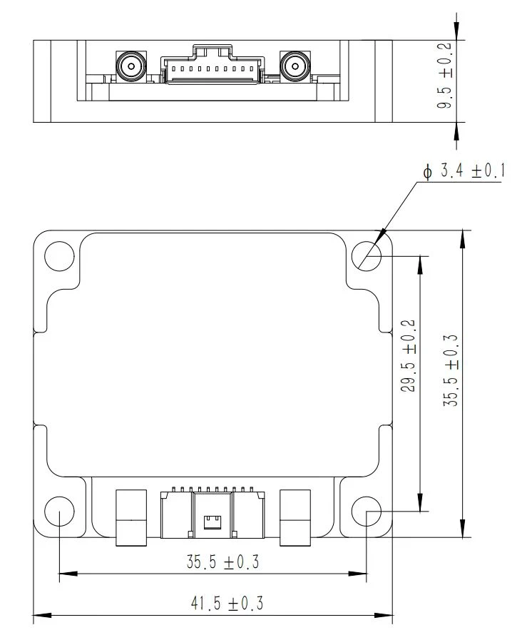
Structural Dimension Drawing
Product Introduction
Product Overview
The MSI105 Micro integrated navigation system is a compact and cost-effective MEMS inertial integrated navigation system, mainly targeting navigation, control, and measurement fields represented by SATCOM-on-the-move and UAVs. The system highly integrates MEMS sensors and full-band satellite receiver chips within a small footprint, enabling positioning and attitude measurement in a compact volume.
Product Features
- High performance, compact size, lightweight
- Full-band GNSS support, high positioning and heading accuracy in complex environments
- Ultra-low power consumption of 0.5 W in steady state
- Full-temperature calibration compensation from -45℃ to +80℃
- Optional adaptive attitude and heading algorithm
- Online software upgrade capability, lever-arm error compensation
- Self-correction algorithm without GNSS, maintaining horizontal attitude accuracy
- RTK differential support
Applications
- SATCOM-on-the-move
- Position and attitude reference for UAV/UGV/USV
- Attitude control
- UAVs and USVs
Technical Parameters
Table 1 MSI105 Micro Integrated Navigation System Performance Specifications
|
MEMS Gyroscope |
|
|
Range (°/s)° |
±300 |
|
Full-Temp. Bias (°/h)° |
≤360 |
|
Bias Stability (°/h, 10s avg.)° |
≤10 |
|
Bias Instability (°/h, Allan) |
≤3 |
|
Bias Repeatability (°/h)° |
≤10 |
|
Angular Random Walk (°/√h) |
≤0.3 |
|
Scale Factor Nonlinearity (ppm) |
≤100 |
|
Cross-Axis Coupling (rad) |
≤0.001 |
|
Bandwidth (Hz) |
≥100 |
|
MEMS Accelerometer |
|
|
Range (g) |
±16 |
|
Bias (mg) |
≤5 |
|
Bias Stability (µg, 10s avg.) |
≤300 |
|
Bias Stability (µg, Allan) |
≤50 |
|
Bias Repeatability (µg) |
≤300 |
|
Velocity Random Walk (mm/s/√h) |
≤50 |
|
Scale Factor Nonlinearity (ppm, ±1g) |
≤300 |
|
Cross-Axis Coupling (rad) |
≤0.001 |
|
Bandwidth (Hz) |
≥100 |
|
Integrated Navigation Accuracy |
|
|
Integrated Horizontal Position (m, 1σ) |
3 m (Single Point), 0.02+1 ppm (RTK) |
|
Integrated Vertical Position (m, 1σ) |
5 m (Single Point), 0.03+1 ppm (RTK) |
|
Integrated Horizontal Velocity (m/s, 1σ) |
0.1 |
|
Integrated Vertical Velocity (m/s, 1σ) |
0.15 |
|
Integrated Heading (°, 1σ, Real-Time) |
0.2 (1m Baseline Dual Antenna), 0.5 (Single Antenna, Dynamic) |
|
Integrated Horizontal Attitude (°, 1σ, Real-Time) |
0.1° (Dual Antenna), 0.2° (Single Antenna) |
|
Electrical/Mechanical Interface |
|
|
Power Supply (V) |
5 V (Ripple ≤ 100 mV) |
|
Steady-State Power (W) |
≤0.5 |
|
Startup Time (s) |
≤3 |
|
Communication Interface |
UART |
|
Max Update Rate (Hz) |
100 |
|
Dimensions (mm×mm×mm) |
41.5×35.5×9.5 |
|
Weight (g) |
<30 |
|
Operating Environment |
|
|
Operating Temperature (°C) |
-40~+85 |
|
Storage Temperature (°C) |
-55~+85 |
|
Vibration (g, RMS) |
20~2000 Hz, 4.08 |
|
Shock (g) |
1000 g/1 ms |
|
Reliability |
|
|
MTBF (h) |
10000 |
Technical Specifications
Structural Characteristics
The mechanical interface of the MSI105 Micro integrated navigation system is shown in the figure:
Dimensions: 41.5mm×35.5mm×9.5mm (L×W×H, excluding connectors).
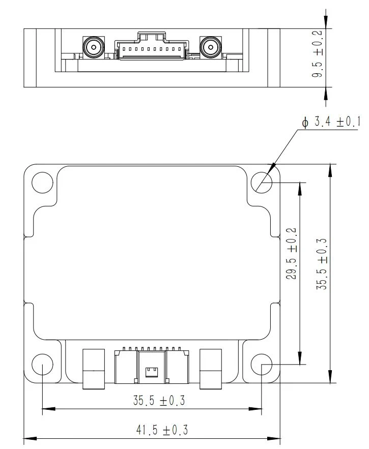
Fig. 2 MSI105 Micro integrated navigation system mechanical interface diagram
Product Marking and Polarity
Place the product horizontally; the arrow indicates the X direction, and the output coordinate system is the "Forward, Right, Down" (FRD) coordinate system.
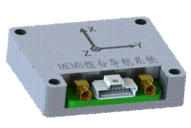
Fig. 4 Vehicle coordinate system definition
Interface Definition
The external interface of the MSI105 Micro integrated navigation system is Molex 501568-1007; the GNSS RF interface is a standard MMCX connector. The external interface definitions are shown in the table below:
Table 3 MSI105 Micro integrated navigation system interface cable pin definitions
|
Pin No. |
Pin Definition |
Interface Definition |
Function Description |
|
1 |
Power Vin+ |
Input Range 5V |
Power Input |
|
2 |
Power GND |
GND |
Power Ground |
|
3 |
UART1_TX |
UART1 TX (Serial 1 Transmit) |
LVTTL Level |
|
4 |
UART1_RX |
UART1 RX (Serial 1 Receive) |
LVTTL Level |
|
5 |
UART2_TX |
UART2 TX (Serial 2 Transmit) |
LVTTL Level |
|
6 |
UART2_RX |
UART2 RX (Serial 2 Receive) |
LVTTL Level |
|
7 |
IMU_TX |
UART3 TX (Serial 3 Transmit) |
LVTTL Level |
|
8 |
IMU_RX |
UART3 RX (Serial 3 Receive) |
LVTTL Level |
|
9 |
PPS_OUT |
PPS Signal Output |
LVTTL Level |
|
10 |
TOV_OUT |
IMU Sampling Sync Output |
LVTTL Level |
After the supply voltage drops below the device operating threshold, the power-off hold time tOFF before re-powering must not be less than 3 s; an insufficient power-off interval may cause abnormal startup, latch-up, or initialization failure.
External Communication
Protocol 1: Integrated Navigation Data Protocol
The MSI105 Micro integrated navigation system outputs data in timed broadcast mode by default, with an output rate of 200 Hz, 164 bytes per frame, a baud rate of 460800 bps, 1 start bit, 8 data bits, 1 stop bit, and no parity. Data is transmitted in little-endian mode with the low byte first. A typical communication protocol is shown below; the protocol can also be customized according to user requirements.
Table 3 Integrated Navigation System Output Communication Protocol
|
No. |
First Byte Offset |
Bytes |
Signal Name |
Unit or Content |
Scale Factor |
Interface Accuracy Description |
|
1 |
0 |
1 |
Frame Header 1 |
Content: 55H |
1 |
8-bit Unsigned Integer |
|
2 |
1 |
1 |
Frame Header 2 |
Content: AAH |
1 |
8-bit Unsigned Integer |
|
3 |
2 |
1 |
Data Length |
Content: A0H |
1 |
8-bit Unsigned Integer |
|
4 |
3 |
4 |
PCNum |
Interrupt Counter |
1 |
32-bit Unsigned Integer |
|
5 |
7 |
1 |
System Status Word |
- |
1 |
Self-test in progress: 0x10, Self-test OK: 0x12, Self-test error: 0x1F, Coarse alignment: 0x33, Fine alignment: 0x35, Pure inertial navigation: 0x41, Zero-velocity correction: 0x43, Velocity+Position integration: 0x44, Velocity+Position+Heading integration: 0x45; Vehicle constrained navigation: 0x46; Odometer integrated navigation: 0x47, Self-calibration in progress: 0x51/0x53/0x55, Self-calibration complete with valid criteria: 0x56, Self-calibration OK written to Flash successfully: 0x57, Self-calibration error: 0x5F. |
|
6 |
8 |
1 |
Real-Time Status Word |
- |
1 |
|
|
7 |
9 |
2 |
Reserved Bytes |
- |
1 |
|
|
8 |
11 |
4 |
Reserved Bytes |
- |
1 |
|
|
9 |
15 |
4 |
X Gyro Angular Rate |
[-1000,1000]°/s, |
0.0000005 |
Mean value over the output period |
|
10 |
19 |
4 |
Y Gyro Angular Rate |
[-1000,1000]°/s, |
0.0000005 |
Mean value over the output period |
|
11 |
23 |
4 |
Z Gyro Angular Rate |
[-1000,1000]°/s, |
0.0000005 |
Mean value over the output period |
|
12 |
27 |
4 |
X Accelerometer Output |
[-400m/s2,400m/s2] |
0.000001 |
Mean value over the output period |
|
13 |
31 |
4 |
Y Accelerometer Output |
[-400m/s2,400m/s2] |
0.000001 |
Mean value over the output period |
|
14 |
35 |
4 |
Z Accelerometer Output |
[-400m/s2,400m/s2] |
0.000001 |
Mean value over the output period |
|
15 |
39 |
4 |
Integrated Longitude |
(-180,180]deg |
0.0000001 |
|
|
16 |
43 |
4 |
Integrated Latitude |
[-90,90]deg |
0.0000001 |
|
|
17 |
47 |
4 |
Integrated Altitude |
[-500,16384]m |
0.00001 |
|
|
18 |
51 |
2 |
Integrated North Velocity |
[-1310,1310]m/s |
0.005 |
|
|
19 |
53 |
2 |
Integrated Vertical Velocity |
[-1310,1310]m/s |
0.005 |
|
|
20 |
55 |
2 |
Integrated East Velocity |
[-1310,1310]m/s |
0.005 |
|
|
21 |
57 |
2 |
Roll Angle |
[-90,90]deg |
0.006 |
|
|
22 |
59 |
2 |
Heading Angle |
[-180,180]deg |
0.006 |
Positive when heading west of north |
|
23 |
61 |
2 |
Pitch Angle |
[-85,85]deg |
0.006 |
|
|
24 |
63 |
4 |
Satellite Longitude |
(-180,180]deg |
0.0000001 |
|
|
25 |
67 |
4 |
Satellite Latitude |
[-90,90]deg |
0.0000001 |
|
|
26 |
71 |
4 |
Satellite Altitude |
[-500,16384]m |
0.00001 |
|
|
27 |
75 |
2 |
Satellite North Velocity |
[-1310,1310]m/s |
0.005 |
|
|
28 |
77 |
2 |
Satellite Vertical Velocity |
[-1310,1310]m/s |
0.005 |
|
|
29 |
79 |
2 |
Satellite East Velocity |
[-1310,1310]m/s |
0.005 |
|
|
30 |
81 |
1 |
Temperature |
[-127,127] |
1 |
|
|
31 |
82 |
1 |
Positioning/Heading Validity |
/ |
1 |
bit0-3, receiver positioning flag: 00 no fix, 01 single-point fix, 02 float solution, 03 fixed solution; bit4-7, heading signal: 00 no heading, 01 single-point heading, 02 float heading, 03 fixed heading. |
|
32 |
83 |
4 |
Satellite Time of Week (s) |
|||
|
33 |
87 |
1 |
Year |
|||
|
34 |
88 |
1 |
Month |
|||
|
35 |
89 |
1 |
Day |
|||
|
36 |
90 |
1 |
No. of Positioning Satellites |
[0,255] |
1 |
|
|
37 |
91 |
2 |
Satellite Track Angle |
[-180,180]deg |
0.006 |
|
|
38 |
93 |
2 |
Dual-Antenna Heading |
[-180,180]deg |
0.006 |
|
|
39 |
95 |
2 |
Reserved |
|||
|
40 |
97 |
14 |
Reserved |
|||
|
41 |
111 |
12 |
Reserved |
|||
|
42 |
123 |
4 |
AU |
m/s2 |
1 |
Upward Acceleration (AU) |
|
43 |
127 |
4 |
AF |
m/s2 |
1 |
Forward Acceleration (AF) |
|
44 |
131 |
4 |
AR |
m/s2 |
1 |
Rightward Acceleration (AR) |
|
45 |
135 |
4 |
heave |
m |
1 |
Relative Heave Displacement |
|
46 |
139 |
4 |
Filtered Output |
na |
1 |
|
|
47 |
143 |
4 |
Filtered Input |
na |
1 |
|
|
48 |
147 |
4 |
Dominant Frequency |
na |
1 |
|
|
49 |
151 |
4 |
Data Time - Integer Part |
- |
- |
|
|
50 |
155 |
4 |
Data Time - Fractional Part |
- |
- |
|
|
51 |
159 |
4 |
Reserved |
- |
1 |
|
|
52 |
163 |
1 |
Checksum |
Low 8 bits of the sum of data length and data bytes |
1 |
Product Precautions
- Pay attention to the product electrical interface definitions. When in use, strictly follow the pin arrangement to avoid incorrect connections;
- The product is a precision measurement device. During operation, avoid impacts, collisions, or other conditions beyond the product's tolerance;
- Installation of the product significantly affects angular rate measurement. To avoid installation errors, the mounting surface must have good flatness;
- To ensure measurement accuracy, the product must be firmly and reliably mounted to avoid measurement errors caused by looseness;
- During installation and use, pay attention to ESD protection; wearing an anti-static wrist strap is recommended;
- Operate strictly in accordance with the requirements of this manual, and ensure the external environment meets the usage requirements. If any problem occurs, do not remove the cover or modify the internal structure of the product; contact our technical personnel promptly.
Hot Tags: msi105 micro mems inertial navigation system, China msi105 micro mems inertial navigation system manufacturers, factory